
Troubleshooting
Every entry here is a real reported failure, with what causes it and what to do.
If yours is not listed, the QGIS Log Messages panel usually says why: open
View → Panels → Log Messages and read the QGIS2WebMap tab.
Installing
Searching the plugin list finds nothing
-
Make sure All is selected on the left of the Manage and Install Plugins window, not Installed.
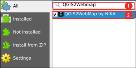
- Check the spelling. It is one word:
QGIS2WebMap. SearchingOnlyMapalso finds it. - If the whole list is empty, QGIS cannot reach the plugin repository — often a workplace firewall. Check Settings → Options → Network for a proxy, then see installing from a file.
It installed, but there is no Web menu entry
- Plugins → Manage and Install Plugins → Installed — confirm QGIS2WebMap by NIKA is there and its box is ticked.
-
If it is there but unticked, tick it. The menu entry and toolbar button appear straight away.
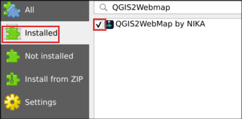
- If it is ticked and still missing, open View → Panels → Log Messages and
read the
QGIS2WebMaptab for an error.
It installs but errors on an older QGIS
The plugin requires QGIS 3.44 or newer. Earlier versions are not supported — not as a policy but as a measured fact: they fail. QGIS 4 is supported.
Check with Help → About.
QGIS closed while I was using it
That is a bug, not a normal outcome. The plugin never closes QGIS, and the only thing it ever installs is the OnlyMap runtime, once, after asking. Please report it with the tail of the Log Messages panel.
The runtime download
It asks to download something. Is that expected?
Yes, once per computer. The OnlyMap runtime is the code that draws the map in a browser, and it is built into every map you export — which is exactly what lets someone open your map with nothing installed. It is a separate commercial product with its own licence, which is why it is fetched rather than bundled into this GPL plugin, and why you are shown the licence first.
About 4.5 MB. After that, everything works offline, and exporting itself never touches the network. See privacy for what that request does and does not send.
The download fails
The download uses QGIS’s own network settings, so check Settings → Options → Network first — a proxy configured there is used automatically.
If outside downloads are blocked entirely, install the runtime by hand:
- On a machine with access, download the package from npm and unpack it.
- Copy the
distfolder — you needonlymap.standalone.jsandonlymapjs.css. - On the offline machine, set the environment variable
ONLYMAP_RUNTIME_DIRto that folder before starting QGIS.
The plugin uses a runtime it finds that way and never asks to download.
The Processing algorithm stops immediately on a new machine
Expected, and it says so. Export to OnlyMap web map cannot show you a licence — there is nobody to show it to during a batch run — so on a computer that has never installed the runtime it refuses rather than downloading silently.
Export once from Web → QGIS2WebMap by NIKA and the algorithm works from then on.
Exporting
Export is greyed out
The reason is printed beside the button. The three you will meet:
| The reason says | What to do |
|---|---|
| Add a vector layer to the project to export. | The project has no vector layer. Raster-only projects have nothing to export |
| Tick at least one layer to include. | Everything is unticked in the Include column on the Layers tab |
| Something else | Open the Fidelity tab. A Blocked item names the layer and the reason |
The Fidelity tab takes a long time to fill
It reads every feature of every layer, so a large project takes a while. The progress bar names the layer it is on. It runs on a background thread — the window stays usable, and Cancel stops it.
Nothing happens when I press Export twice
By design. One job runs at a time, and both buttons go dark while it runs, so a second press cannot start a second export.
The exported file is enormous
Standalone HTML writes every feature into the file itself. That is what makes it self-contained, and it is inherent to the format — a map with 20 MB of data produces a file of at least 20 MB.
In order of how much they save:
- Untick Popups on layers whose attributes nobody needs. Those values leave the file entirely.
- Untick Include on layers that are not carrying their weight.
- On the Map tab, tick Export only the features in this view to drop everything outside your current extent.
- Set Coordinate precision to 6 decimal places. This is irreversible; six places is about 0.1 m at the equator.
- Switch to Share ZIP, which compresses the same map.
Opening and sharing
The map is blank, or shows a message about JavaScript
You are looking at it somewhere that does not run JavaScript — an email client’s preview pane, a file manager’s preview, a chat app’s inline viewer. The message is deliberate; a blank window would be worse. Save the file and open it in a browser.
Double-clicking the Folder export does not work
Correct, and it cannot. Browsers refuse to load the runtime from a separate file
on a file:// page. The Folder mode exists for uploading to a web server.
Use Standalone HTML for anything that has to open off a disk.
The map never arrived / the attachment was stripped
Many mail providers and corporate filters quarantine or remove .html
attachments, because HTML is a common phishing vector. This is the single most
common delivery failure.
Export as Share ZIP instead. A zip usually passes filters a bare .html does
not, and it carries a short README telling the recipient how to open it.
The recipient says features are missing
Check the Fidelity tab against that layer. The usual causes:
- Export only the features in this view was ticked, and the missing features were outside your QGIS extent at export time.
- The layer is unticked in Include.
- The map is being served from a real domain and is over the free plan’s limits — see below.
Hosted maps
None of this applies to a file someone double-clicks, emails, or opens from
localhost. Those draw everything, with no licence key.
Layers past the fifth do not render, or a layer is truncated
The OnlyMap free plan allows 5 layers per map and 25,000 features per
layer, and those limits apply only to a page served over http(s) from a real
domain. A layer past 25,000 features is truncated to its first 25,000 while still
looking complete, which is why the Fidelity tab names every layer over a limit
before you host.
An OnlyMap licence key lifts the limits and removes the on-map badge. Supply it
through the ONLYMAP_LICENSE_KEY environment variable or the Processing
algorithm’s licence parameter. Lifted limits are a technical convenience and not
a licence grant — commercial use needs a key either way. See
size limits on the free plan.
The map is blank on my own site but fine locally
Your site’s Content Security Policy. The map’s styling is driven by
expressions the runtime evaluates at draw time, so a policy without
'unsafe-eval' in script-src stops it rendering — not partly, entirely. See
hosting.
Basemap tiles do not load for the recipient
The tiles come from the provider’s servers on every open, so the recipient needs internet access and an unblocked route to that provider. If you need a map that works with no connection at all, set Basemap to None — the default.
Still stuck
- Open an issue, with the
QGIS2WebMaptab of the Log Messages panel and your QGIS version - Email support@nikaplanet.com